I know this has been asked before, but which hiking/trail/map app do you use?

cubrock

Swell guy
2A Bourbon Hound 2024
2A Bourbon Hound OG
Charter Life Member
Benefactor
Multi-Factor Enabled
Joined
Dec 18, 2016
Messages
10,113
Location
Hickory, NC
Rating - 100%
38   0   0
Looking for one I can use around here (Linville Gorge, Smokies) and also the Bob Marshall Wilderness, where we are headed this summer. Figure I better get one loaded and get proficient with it now so it is a no brainer this summer when we head west.

I know this has been asked before, but I didn't find the relevant threads when I tried searching for them.

Thank you!

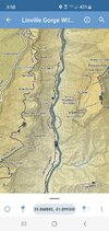
For Linville Gorge, I like Avenza the best. You download the Avenza app, then download the free maps for it. There is also one for the Wilson Creek area.
 
What I like best about the maps you download and use with Avenza for Linville Gorge is that it has all of the names and locations of many features such as rock formations, points of interest, sources of water, etc.
 
Thank you! I've just downloaded the app and will check it out. Looks like they have map sets for The Bob available for a reasonable price, too.
 
USGS Topo map. Carry one as well as the app so when your batteries die you still have a map. Carry a compass too and know how to use it. I am all about the tech while it’s working but have a back up too.
 
USGS Topo map. Carry one as well as the app so when your batteries die you still have a map. Carry a compass too and know how to use it. I am all about the tech while it’s working but have a back up too.


Loud and clear. The app is simply for convenience of logging trail miles, etc. I'm well versed in the use of a paper map.
 
not exactly what you are looking for, but if you havent seen the peakfinder app it’s pretty cool

 
Avenza uses the Nat Geo maps that you buy in the store too. The digital map is about the same price as the hard map. For most areas I go I have both. I just created an account with Alltrails too. They have better maps of south mountains with navigation. Last I checked Avenza had nothing for south mountains state park.

The only place I have had trouble with Avenza is in Lost Cove near the bottom of the cliffs area. I was fishing and the track was really wondering around. But I've been close to the furthest place from a road you can get in NC, in the Smokies. Had no cell service but Avenza tracked just fine there.

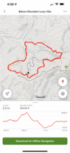
Avenza is my go to on the trail. Alltrails is fantastic for planning trips. They have some great elevation models that can be moved along to match the point on the map. Hard to explain but a really cool feature for planning.

Screenshot of the elevation feature.


7A64B6A4-DEA1-458F-8126-26F13F49DE44.png
 
Last edited:
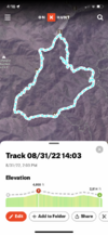
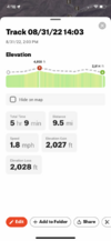
Late to the discussion but been hiking this year with a couple neighbors trails in and around Haywood County/BRP and the Cataloochee area. One of my hiking buddies uses alltrails. I’ve been using onXhunt. It has a great tracking feature that shows your starting point and dots along the trail as you hike. Plots mph, length of your hike, elevation gains and losses. Has layers you can choose to show, like elevation lines, property borders, etc. You can input gps coordinates and set waypoints to hike to a specific point. (This helped us hike to the old plane crash site near Browning Knob).
Works offline so signal is not an issue.
Here’s the saved file from a recent hike:
B835FB19-096B-49EE-A770-CDF75AD56A4C.png354768F4-B8ED-4A9E-BC8D-080216469394.png
 
The third guy in our hiking group has been hiking these hills for 40 years. He always carries paper maps but it’s amazing how much he recalls just from memory.
 
Back
Top Bottom