cubrock
Swell guy
2A Bourbon Hound 2024
2A Bourbon Hound OG
Charter Life Member
Benefactor
Multi-Factor Enabled
I turn 50 tomorrow. I decided I wanted to do something epic for my 50th birthday and was going to solo The Grand Loop around Linville Gorge, but scheduling just didn’t work. So, I decided I would solo the Is That All You Got Loop in the Gorge on my birthday. It is roughly 22 miles, crossing the Linville River at the Spence Ridge Trail and again at the bottom of the Gorge on the MST. Most people take two or three days to do it.
My two younger boys (the hiking machines) got wind of it and said they would do it with me if I could go the Saturday before my birthday , which was yesterday. Of course I will change my plans to have company!
I took video on the trail, but not as many pics as normal. And the video got sparse the second half. This loop is tough! I’d been training for this since we got back from the Montana backpacking trip in July. I would ruck Hibriten Mountain with a 30 pound plate on Mondays and then hike 14 miles in the Gorge on Wednesdays. Those 14 miles were the first seven miles of the loop out, then turn around and go back to the parking area.
The route we took started at Wolf Pit parking area, up Shortoff Mountain, pick up the MST and hike it to the base of Table Rock, turn on to Little Table Rock Trail to Spence Ridge Trail, Spence Ridge down to the river where we crossed the river and started southwest on the Linville Gorge Trail. Take it to Lead Mine Trail, Lead Mine to the MST again, which we took across the river to the Fonta Flora connector, then back up to Wolf Pit on the Faulkner Flats Trail.
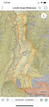
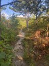
There are plenty of places along this route that are fairly easy hiking, like along the top of Shortoff Mountain, or the southern part of the Linville Gorge Trail, but you pay for them in sweat and toil on the ascents and descents in between. And even where the trail slope isn’t horrible, trail conditions can really make you work - overgrown brush you have to push through, downed trees on the less maintained trails, and rocky sections where you can never get a good stride due to having to constantly watch your footing. LOTS of all of that.
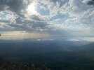
We hit the trail at 5:45 in the morning and hiked up Shortoff Mountain with headlamps. We got well along Shortoff in time for a brilliant sunrise.


The rising sun illuminated Table Rock Ridge and I had to stop for a picture.
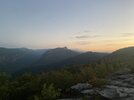
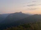
We are headed that way and have about 5 miles to go to the Table Rock parking area. We carried extra water so we wouldn’t have to stop and filter along this stretch. The watering holes from here to past the parking area are inconvenient.
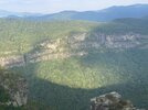
Near the top of the MST’s ascent from Chimney Gap (the gap between Shortoff Mountain and Table Rock Ridge) is a rock promontory that affords a great view eastward. The climb up from Chimney Gap is brutal, and stopping at this rock for a picture lets you catch your breath for the last couple tenths of a mile of the climb.
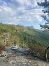
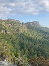
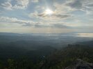
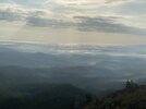
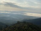
The camera just couldn’t capture the view. It took my breath away and almost looked like a view from Heaven. The trails themselves were often beautiful as the rising sun caught the changing leaves.
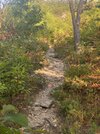
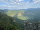
Once you get to the top of Table Rock ridge, things flatten out and you get a bit of a break. As you approach The Chimneys, it gets rough again, but in more of a rock scrambling, broken trail way. I was feeling the hike by this point, and we were less than a third of the way through. The views from the ridge were spectacular.
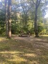
We got to Table Rock parking area around 9. We stopped at a picnic table for second breakfast. We passed a lot of rock climbers headed out for the day along this section of trail and there was practically a climber party in the parking lot. I videoed our walk through the parking lot, but didn’t get any pics.
From the parking area, we hiked up the Table Rock Trail until we took a left on Little Table Rock Trail. You immediately start descending into the gap between Table Rock and Hawksbill and you go down, down, down. It is steep and just goes and goes. This is where my knees started protesting. There are places along this trail where you slide more than hike. I was SO glad that we were going down instead of up. The trail is beautiful, though, going through stands of mature hardwoods. Lots of white oaks and there were acorns all over the place. I bet the deer love this part of the gorge.
We finally hit bottom and crossed a creek, which was the first reliable and convenient water we had seen since the other side of Shortoff (a watering spot called Gully Pipe). We immediately climbed a small ridge and went back down where there was another creek with some great campsites. If you were hiking in from the Spence Ridge parking area, these sites would be easy to reach with just a couple or three miles of hiking. Great hammock trees and great tent sites. Really nice.
From there, we climbed again, following an old logging road up to Spence Ridge Trail. The climb is easy and the trail easy on the feet, which was a welcome respite. Then we hit Spence Ridge and descended for a mile and change to the river. By this point, I was getting tired enough that I was all business and took way fewer pictures than I had planned.
Spence Ridge trail follows a creek and has some great campsites at the top and again at the bottom. In the middle, the trail is well above the creek and the terrain between the two is very steep. At the bottom is one of the precious few river crossings in the gorge, but you can’t take it for granted you can cross there. There used to be a cable bridge, but a flood washed it out years ago.
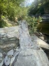
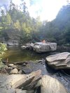
Now, you either have to wade (up to waist deep or deeper in places) or rock hop (some of the “hops” are 4-5 feet wise). Either way, the water has to be low enough to make it safe. The rule of thumb is that it is safe to cross here when streamflow at the Linville River gauge at Nebo is 150 cfs or less. When we checked it before the hike, it was 67 cfs and the crossing was challenging enough. Perhaps there is a place to cross that we didn’t find that would be easier, but we made it. The last jump was a doozy for me. I was glad we had daypacks that were easy to toss across the jumps. Would have been way harder with full sized packs.
This is the crossing we took, looking from west to east. Those guys had a cherry camping spot on that boulder. The cable bridge ran from where we stood to that boulder, from what I understand. From there, the rock hopping is easier than between where we are and that boulder.
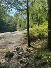
Here, we picked up the Linville Gorge Trail, a trail that runs from the southern end of the gorge, following the river to the north end. I’ve hiked the LGT many times on the southern end, from where the Cambric Trail hits the river down to the Lead Mine Trail. The LGT on this southern section is an easy trail, with no big climbs and generally good footing. I didn’t expect how different the LGT would be north of Cambric, but I found out this day. It hugs cliff faces, has sections of vertical climbs using tree roots like ladders, climbs ridges of huge boulders, goes up and down and up again, all while hiking downstream. In some places, it is little more than a goat path. We were nearly at the half way point when we hit the LGT and I was feeling the miles. The next few miles really wore me down. To top it off, we didn’t stop and filter water before crossing the river, only to discover almost all the watering spots on this section of the LGT were bone dry. So, we hiked on rations until we finally found a watering hole miles down river. Much of the trail food we packed goes down only with water, so we weren’t stopping to eat on that stretch, either, even though our bodies were telling us to. Thank God for Tootsie Rolls. I had a small baggie of them that I’d dip into every half hour or so to keep some easy energy in my system.
One of the boulders that IS the trail is shown here:
At one point, two F16s flew directly over our heads not far above the tree tops. They were so close that you didn’t have to look in front of the sound to see them, like you usually do. The noise was painfully deafening, but it was cool to see. We’ve seen fighter jets do the Mach Mile in the gorge before, but never this close.
As we approached the Cambric crossing, where the LGT would get easier, we discovered a gorge resident. One of my sons walked within inches of him without seeing him. My other son spotted him just before I did. We encouraged him to move off trail with a long stick. He didn’t want to leave his sunbeam. 11 or 12 rattles and 3.5-4 feet long
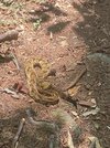
I talked with the boys about how we were in his home and he wasn’t in our campsite, so we would respectfully pass through and leave him be. No sense in shooting a snake unless you absolutely have to.
We hiked to a little waterfall just south of Daffodil Flats where we stopped to eat a later-than-expected lunch and to filter water.
(Continued in next post)
My two younger boys (the hiking machines) got wind of it and said they would do it with me if I could go the Saturday before my birthday , which was yesterday. Of course I will change my plans to have company!
I took video on the trail, but not as many pics as normal. And the video got sparse the second half. This loop is tough! I’d been training for this since we got back from the Montana backpacking trip in July. I would ruck Hibriten Mountain with a 30 pound plate on Mondays and then hike 14 miles in the Gorge on Wednesdays. Those 14 miles were the first seven miles of the loop out, then turn around and go back to the parking area.
The route we took started at Wolf Pit parking area, up Shortoff Mountain, pick up the MST and hike it to the base of Table Rock, turn on to Little Table Rock Trail to Spence Ridge Trail, Spence Ridge down to the river where we crossed the river and started southwest on the Linville Gorge Trail. Take it to Lead Mine Trail, Lead Mine to the MST again, which we took across the river to the Fonta Flora connector, then back up to Wolf Pit on the Faulkner Flats Trail.

There are plenty of places along this route that are fairly easy hiking, like along the top of Shortoff Mountain, or the southern part of the Linville Gorge Trail, but you pay for them in sweat and toil on the ascents and descents in between. And even where the trail slope isn’t horrible, trail conditions can really make you work - overgrown brush you have to push through, downed trees on the less maintained trails, and rocky sections where you can never get a good stride due to having to constantly watch your footing. LOTS of all of that.
We hit the trail at 5:45 in the morning and hiked up Shortoff Mountain with headlamps. We got well along Shortoff in time for a brilliant sunrise.


The rising sun illuminated Table Rock Ridge and I had to stop for a picture.


We are headed that way and have about 5 miles to go to the Table Rock parking area. We carried extra water so we wouldn’t have to stop and filter along this stretch. The watering holes from here to past the parking area are inconvenient.
Near the top of the MST’s ascent from Chimney Gap (the gap between Shortoff Mountain and Table Rock Ridge) is a rock promontory that affords a great view eastward. The climb up from Chimney Gap is brutal, and stopping at this rock for a picture lets you catch your breath for the last couple tenths of a mile of the climb.


The camera just couldn’t capture the view. It took my breath away and almost looked like a view from Heaven. The trails themselves were often beautiful as the rising sun caught the changing leaves.

Once you get to the top of Table Rock ridge, things flatten out and you get a bit of a break. As you approach The Chimneys, it gets rough again, but in more of a rock scrambling, broken trail way. I was feeling the hike by this point, and we were less than a third of the way through. The views from the ridge were spectacular.


We got to Table Rock parking area around 9. We stopped at a picnic table for second breakfast. We passed a lot of rock climbers headed out for the day along this section of trail and there was practically a climber party in the parking lot. I videoed our walk through the parking lot, but didn’t get any pics.

From the parking area, we hiked up the Table Rock Trail until we took a left on Little Table Rock Trail. You immediately start descending into the gap between Table Rock and Hawksbill and you go down, down, down. It is steep and just goes and goes. This is where my knees started protesting. There are places along this trail where you slide more than hike. I was SO glad that we were going down instead of up. The trail is beautiful, though, going through stands of mature hardwoods. Lots of white oaks and there were acorns all over the place. I bet the deer love this part of the gorge.
We finally hit bottom and crossed a creek, which was the first reliable and convenient water we had seen since the other side of Shortoff (a watering spot called Gully Pipe). We immediately climbed a small ridge and went back down where there was another creek with some great campsites. If you were hiking in from the Spence Ridge parking area, these sites would be easy to reach with just a couple or three miles of hiking. Great hammock trees and great tent sites. Really nice.
From there, we climbed again, following an old logging road up to Spence Ridge Trail. The climb is easy and the trail easy on the feet, which was a welcome respite. Then we hit Spence Ridge and descended for a mile and change to the river. By this point, I was getting tired enough that I was all business and took way fewer pictures than I had planned.
Spence Ridge trail follows a creek and has some great campsites at the top and again at the bottom. In the middle, the trail is well above the creek and the terrain between the two is very steep. At the bottom is one of the precious few river crossings in the gorge, but you can’t take it for granted you can cross there. There used to be a cable bridge, but a flood washed it out years ago.

Now, you either have to wade (up to waist deep or deeper in places) or rock hop (some of the “hops” are 4-5 feet wise). Either way, the water has to be low enough to make it safe. The rule of thumb is that it is safe to cross here when streamflow at the Linville River gauge at Nebo is 150 cfs or less. When we checked it before the hike, it was 67 cfs and the crossing was challenging enough. Perhaps there is a place to cross that we didn’t find that would be easier, but we made it. The last jump was a doozy for me. I was glad we had daypacks that were easy to toss across the jumps. Would have been way harder with full sized packs.
This is the crossing we took, looking from west to east. Those guys had a cherry camping spot on that boulder. The cable bridge ran from where we stood to that boulder, from what I understand. From there, the rock hopping is easier than between where we are and that boulder.

Here, we picked up the Linville Gorge Trail, a trail that runs from the southern end of the gorge, following the river to the north end. I’ve hiked the LGT many times on the southern end, from where the Cambric Trail hits the river down to the Lead Mine Trail. The LGT on this southern section is an easy trail, with no big climbs and generally good footing. I didn’t expect how different the LGT would be north of Cambric, but I found out this day. It hugs cliff faces, has sections of vertical climbs using tree roots like ladders, climbs ridges of huge boulders, goes up and down and up again, all while hiking downstream. In some places, it is little more than a goat path. We were nearly at the half way point when we hit the LGT and I was feeling the miles. The next few miles really wore me down. To top it off, we didn’t stop and filter water before crossing the river, only to discover almost all the watering spots on this section of the LGT were bone dry. So, we hiked on rations until we finally found a watering hole miles down river. Much of the trail food we packed goes down only with water, so we weren’t stopping to eat on that stretch, either, even though our bodies were telling us to. Thank God for Tootsie Rolls. I had a small baggie of them that I’d dip into every half hour or so to keep some easy energy in my system.
One of the boulders that IS the trail is shown here:

At one point, two F16s flew directly over our heads not far above the tree tops. They were so close that you didn’t have to look in front of the sound to see them, like you usually do. The noise was painfully deafening, but it was cool to see. We’ve seen fighter jets do the Mach Mile in the gorge before, but never this close.
As we approached the Cambric crossing, where the LGT would get easier, we discovered a gorge resident. One of my sons walked within inches of him without seeing him. My other son spotted him just before I did. We encouraged him to move off trail with a long stick. He didn’t want to leave his sunbeam. 11 or 12 rattles and 3.5-4 feet long

I talked with the boys about how we were in his home and he wasn’t in our campsite, so we would respectfully pass through and leave him be. No sense in shooting a snake unless you absolutely have to.
We hiked to a little waterfall just south of Daffodil Flats where we stopped to eat a later-than-expected lunch and to filter water.
(Continued in next post)

Last edited:


