
You are using an out of date browser. It may not display this or other websites correctly.
You should upgrade or use an alternative browser.
You should upgrade or use an alternative browser.
OFFICIAL BOAT PICTURE THREAD!
- Thread starter JRHorne
- Start date
- Replies 88
- Views 5,860


More money than sense it appears. Glad nobody lost their lives but that hurts knowing that yacht was totaled. When we retire and hit the water our plan is 10 knots. We aren't going to be in a hurry to get anywhere.We didn't know anything until two weeks later and we got a call from our broker that handled the sale. Our man had run the 420 up hard on the jetty in Charleston going in that night, and sunk the boat, total loss. Coast Guard responded out of Charleston, lucky no one was seriously injured.
Ever been on the Dismal swamp canal? There is a LOT of history on the waterway.
Last edited:
Looks like you need to change your screen name.

In my post above I said that I have not used my boats much. The 2004 SeaPro in 2018 had 456 hours on it and I just got it back from the shop for a tune up and had 466 hours on it. When I used to fish offshore in that boat I would put 10 to 12 hours on it in one trip.
More money than sense it appears. Glad nobody lost their lives but that hurts knowing that yacht was totaled. When we retire and hit the water our plan is 10 knots. We aren't going to be in a hurry to get anywhere.
Ever been on the Dismal swamp canal? There is a LOT of history on the waterway.
10 knots is just dandy, and there really should be no need to get in a hurry if you are on the boat. What is the point? I am not a go fast sort of boater.
Never in the Dismal Swamp. Our waters range from Wilmington to Charleston. I love the Cape Fear, it is great water, wide and deep. When we got good water like that we do get up to cruise which is 20 knots or so. At 10 knots we only burn around 8-10 gallons per hour. At cruise we burn around 35 gallons per hour and WOT I have seen it hit 32 mph burning 65 gallons per hour...... We don't run WOT at all, last time was during Sea Trails when we bought the boat. LOL............... Cruise speed is plenty fast enough.
Knotright, yeah, need to run a little more I think....... We average about 100-120 hours per year on the two Breezes...... Now thankfully only One. We call Grand Dunes Marina home port. It is the closest Marina to our home and we can be on the boat in 20-22 minutes from home. That is really great. However, there is a few major downsides to that area. It is right in the middle of the "Ditch" as we call it. The 20+ mile stretch of the Waterway that was dug out. We are dead in the middle, and in between the two swing bridges, north at Little River, and south at Socastee. Roughly 10-11 miles to both, in either direction. The Ditch, its not very scenic, or just extremely nice water to run in. And you are not going to get anywhere in any hurry, its houses, docks and boats the entire way, mostly NO WAKE areas......... 8-10 mph top end, or we throw way too much wake up. So its an hour+ south to the Socastee swing bridge, then only a couple of miles further to where the Waccamaw comes in, and from there to Georgetown is some fantastic scenery and great water running from 15-35 feet all the way to GT. Very nice run, once you get past the damn bridge. But you run and hour + in the ditch!
Going North its the same, about 1 hour and 15 minutes to the Little River bridge. Same story, mostly no wake. But worse than going south we have the most dangerous part of the Intracoastal Waterway, the famous "Rock Pile". The Rock Pile area is really about 2 miles or less, but it is the most dangerous part of the entire Intracoastal, so I am told anyway. It is narrow, and the sides and bottom are lined with granite. High tide, much of that is submerged. So you stay dead in the middle, and you are very cautious about how much you give way. I don't give much, very little. And I will not give way to smaller vessels at all. Larger vessels than us, if we feel like we can't give way, we turn our ass around and go back until we can give way safely. I have been fairly cautious in this stretch of water. Always leaving early morning when less vessels are out. I also have a app and website that shows tugs and barges that might be in the area, I check that too before leaving. Fortunately I have never met a barge in that stretch, but should I ever, my ass will be turning the Breeze around, and headed out until I can give way enough without being in the Rock Pile.
Once you get North of Little River, the scenery gets better, but there are so many houses, docks and no wakes you cannot cruise for nothing. Its a total of 5 hours from MB to Southport for us, in the Breeze. Slow running. But like Silvr says, no need to be in a rush. I don't have a tremendous amount of Off Shore experience, have mostly run inside. But in the future I am going to give it a go in some of these trips, if it is nice, and I mean 2 ft seas or less! My Rule of Thumb, 2 ft or less is good, anything more I am SCARED......... LOL..... It would only be about an hour cruise from Little River Inlet to SouthPort running outside. With good water.........
Going south to Charleston is extremely scenic the entire stretch of Waterway. It is just beautiful and fairly wild. Not a lot of houses, boat docks and marinas. But it too is a very slow go for us, the water depths are TERRIBLE and you can only go in some areas at high tide. You must plan that stretch for High Tide at McClellanville, and even then it can be a little touchy feely. If you go through this at high tide you are in fair shape with 3-4 ft of water under the boat. We draft 4 feet. I have come through stupid at 3 hours before low tide, and sweat bullets, many times with 1 ft under the boat. Never again, high tide or no go......... This would be another stretch I will opt for running outside from GT to Charleston in the future, IF I HAVE 2 ft seas.......
We love it, love being on the boat. But we do have to pick and choose our times, when we get the time........ While being at the Dunes is great, as it is short ride from home, we are trapped in the ditch and between the bridges, so it is just not all that much fun to go on that spur of the minute boat ride, and not much of anywhere to go if you do.............
One thing we are looking very much forward to, currently we are at the end of one of the docks, on the T...... There is another 50 ft Sea Ray Sports Cruiser behind us. There is only about 1.5 feet between our aft platforms. Little tight. But he is moving to the slip just on our port side currently. When he makes that move, we are taking the entire T Dock, so no one will be behind us at all in the future, we have the entire dock on that side.
In the photo below you see both the Cool Breezes when we had two.... Well the spot where the 420 is in the photo is where the Sport Cruiser is now, when he leaves, we have the entire dock........ Nice!

I look for him to take a Shit Fit and buy the whole damn dock any day...………………..
I look for him to take a Shit Fit and buy the whole damn dock any day...………………..
Well, I have not asked about buying the whole thing yet. But I have had dibs on the entire end on the T since that chap moved in behind me! Get rid of him, then that is a done deal..... Won't be anyone else behind again.
@Michael458 If you ever want to take a longer trip south, head to Savannah. Can arrange dockage on River Street or I can see it I can get a space at the Savannah Yacht Club. Running outside from Charleston is about 8 hours. I have been to Charleston via the ditch and it took forever. When my friend had a 36' Yellowfin in MB (right above maybe Little John River), we took it down to Pawley Island via the ditch and do not see how 2 bigger boats could pass side by side and we got into some really skinny water in a number of places in the ditch.
Michael, does your boat have the joy stick steering? We took a 48 Sea Ray from Savannah to Beaufort for lunch and the boat had the joy stick. It was amazing seeing how easy it was to dock.
Michael, does your boat have the joy stick steering? We took a 48 Sea Ray from Savannah to Beaufort for lunch and the boat had the joy stick. It was amazing seeing how easy it was to dock.
Last edited:
Michael, does your boat have the joy stick steering? We took a 48 Sea Ray from Savannah to Beaufort for lunch and the boat had the joy stick. It was amazing seeing how easy it was to dock.
Knotright.. No joystick. But it does have bow and stern thrusters. Sea Ray comes standard with bow thruster, but I installed a SideShift stern thruster after we got the boat. It is a "Breeze" to dock with it. It was not bad without the Stern thruster, but I don't mind cheating at all and making things easier. I bought the biggest thruster SideShift makes and it works pretty good, I was hoping for more, but it does very well.
Thank you for the Savannah offer, I might just drop you a note one day. We would love to have TIME to do that. ONE DAY...... We hope to travel South to Florida and dock up for Winter, then head back to MB in early spring. But we are not there yet!
A pipe dream of mine is to possibly do the Great Loop someday. Have to see how that goes.
That would be an incredible trip. I am pretty sure I will never have the time to do that one.........Keep the dream close, you never know!

Currently in New Bern, NC. Had to go over to the marina and look at the boats. Nice old Hatteras flush deck trawler I’d like to have. I didn’t get a good picture of it. Good excuse to go back and see it again.
Last edited:


This was my Christmas present to myself last year. 18.5ft Express. And Sheeba, my boat buddy. Ran into the Dolphins 2 weeks ago, they were all over the place.View attachment 150089 View attachment 150090 View attachment 150091 View attachment 150088
I had/have an Express 19’ with a 200 HP Yamaha that has been flawless for almost 15 years now. Good boats.
BigTwig
Beach bum
2A Bourbon Hound 2024
2A Bourbon Hound OG
Charter Member
Life Member
Multi-Factor Enabled
This was my Christmas present to myself last year. 18.5ft Express. And Sheeba, my boat buddy. Ran into the Dolphins 2 weeks ago, they were all over the place.View attachment 150089 View attachment 150090 View attachment 150091 View attachment 150088
Great boats!! My hunting buddy has the same one and that is what we use for duck season
Ok, so Ill fess up, my boat was the smallest one in the picture above. Probably the most fun though.

Best time of year to be on the water though. Had the entire north end of Figure 8 to ourselves this past Sunday afternoon. We found a few treasures like this:

Probably the most fun though.
Best time of year to be on the water though. Had the entire north end of Figure 8 to ourselves this past Sunday afternoon. We found a few treasures like this:
Ok, so Ill fess up, my boat was the smallest one in the picture above.
In many ways you are correct............ The bigger the boat, the less it gets out. And your options of what and where you can explore are more limited...............
Last edited:
Taking the Breeze on a short trip today. We finally now have the complete T Dock to ourselves. 90 feet of Dock. The other boat moved about two weeks ago, but in the process of him moving his boat, he got confused between forward and reverse and hit the Breeze on the swim platform doing some minor damage. Damn! While it is rather minor, I want it repaired, and that has not been a problem at all, and the other fellow is paying for everything of course. The problem is, to do a proper repair the boat needs to be hauled out of the water. I hate hauling a boat! I was going to have it hauled in about a year to have the bottom painted, so we decided to haul the boat, his expense, and go ahead paint the bottom while it was out, and any other repairs that might be needed while it was out of the water. This way, get everything done, and if no issues it won't have to come out for 3 years or so.
Short trip about 12 miles north to the new Cherry Grove Marina, used to be the Old Anchor Marina. New management and according to what I have heard some vast improvements. We have to navigate an area about 2 miles or so of the most hazardous water on the entire waterway, so they say. Called the "Rock Pile"........ Narrow, and solid granite on all sides, much of it hidden just below the water. Many a boat been destroyed and damaged in this stretch. I hate it. Been through several times, and its always nerve wrecking. Slow go, max 10 mph. And hope to god you don't meet anything bigger than you are coming through.
Have to wait until high tide to have enough water to haul, so leaving dock at or around 1:30 this afternoon, takes a little over an hour to get there in this stretch. No loading or shooting today...............
Back in the water tomorrow........... Been Dry Docked for 10 days tomorrow. New Bottom Paint, Repairs done on swim platform, new hoses and seals on thru hull's, and ready to go back in. Keeping close at the lift for a couple of days to make sure new seals and hoses are good to go before heading south back to our home dock. Weather looks good for a Monday run back home..........................


We actually made that run home on the 18th, I had only been back on the compound about an hour when we had all the CFF Visitors............. As many of you know, the weather was not so great for any sort of boating on Saturday the 19th and Sunday the 20th. In fact, they were calling for some nasty winds. The Docks at NMB were not in good shape either, I did not want to leave the Breeze on those docks in bad weather. So we decided to make a run back to home dock and get secured that day...........


Then, once we set her in the water we started up the Gen Set, turned on all the Battery Chargers, checked everything, started Port Engine.............. And then attempted to start Starboard, but batteries were down, and or stone cold dead. Even emergency startup, pulling power from Port Engines to Starboard for startup, killed the systems. We sat there, ran Port and Gen Set for about 30 minutes, and finally got Starboard started. During this time we made plans to have ALL BATTERIES REPLACED. After Starboard warmed up nice, and all looked good, I killed it to make sure it would start again if we had an issue on the run back to home port. It started, so all was good. The run home was uneventful, which is good, we quickly tied up with plans to return Saturday morning to secure the Breeze before the afternoon winds were set to come in.
As mentioned, the main reason we hauled the boat this year was because the fellow hit the swim platform aft when he moved his boat off our dock. His cost on that totaled to $1400. Well, when we hauled the boat, I saw some cracks and an old repair that was done on the swim platform from the previous owner, that I really had not paid attention to in the past. So I had that repaired as well, that cost me $1350.00......> LOL......>> But the swim platform looks as good as it did when the boat was new. So all good....................
We painted the bottom, it was not due for bottom paint for a year, but while I had it out, get it done now, and won't have to haul again for at least 3 years or better........ We put some extremely good paint on, nothing cheap, $280 per gallon. Total on the bottom paint job ended up at $5158.00
I also had my guy wax the boat while it was out, at least the hull. He finished the top side this week, and then washed and cleaned....... $1200.00 and we wax twice a year, and wash and clean outside every month.
Now also, while it was out of the water, I had my guys replace all Thru hull fittings, seals and new hoses. And today, they are putting in all new batteries............. Hmmmm....... Don't have that invoice yet...........
Boats are not cheap...............
@Michael458 your post just confirmed that old saying: A boat is just a hole in the water to pour money into. LOL But if you enjoy it, it really doesn't matter.
@Michael458 your post just confirmed that old saying: A boat is just a hole in the water to pour money into. LOL But if you enjoy it, it really doesn't matter.
No doubt about it............... it never ends I promise you. Insurance, Dock Fees, washing/waxing, and just basic upkeep is insane........But we do love it and enjoy it a lot. When the day comes that we no longer use or enjoy the boat, then it is time to make a change. Before too much longer our youngest will be independent from every day care, and we will be able to spend more time on the boat. But we knew that going in. Limited now to weekends and off days from school and such. But we will have off to college in another couple of years and we will have more time.............I HOPE..........
Not exactly a "boat", since the Navy insists on calling it a "ship" if it's capable of conducting sustained independent operations at sea, but she was my first. Also, these are my photos - taken from the open back door of the SH-60B after coming back from a photo recon mission during Desert Storm/Desert Shield operations. USS Carr (FFG-52) was commissioned on 27 July 1985 and decommissioned on 13 March 2013. She was 450 ft long, 45 ft at the beam, twin GE LM-2500 gas turbine engines, a crew of 190 (plus officers), with two helo hangars for carrying up to two SH-60Bs and the associated flight and maintenance crews, a single-armed bandit missile launcher for Harpoon and SM1-MR missiles, the 76mm main gun, torpedo tubes, etc.


Rob
Well-Known Member
2A Bourbon Hound 2024
2A Bourbon Hound OG
Benefactor
Life Member
Supporting Member
Multi-Factor Enabled
USS Carr (FFG-52) was commissioned on 27 July 1985
I LIKE.......... Glad I am not 100% responsible for the upkeep....................
Still Out there...???
the 76mm main gun
Hmmmm......... I have a 9mm Shield and a 8.5 inch 300 BLK on board.........I reckon thats a long way from 76mm, even added together....... LOL.....................
Less firepower than this ∆∆∆∆
But, I allow alcohol and coed bunking!
My wife would love that boat......... More details please...... Where do you keep it.....?
I LIKE.......... Glad I am not 100% responsible for the upkeep....................
Still Out there...???
Sadly, all of the Perry class frigates have been decommissioned (before their usefulness expired, in my opinion). The Carr is in mothballs at the Philadelphia Naval Shipyard, I believe. Many of the hulls were sold to other countries to upfit and continue service in their navies.
Sadly, all of the Perry class frigates have been decommissioned (before their usefulness expired, in my opinion)
Figures........ Too bad..........
Rob
Well-Known Member
2A Bourbon Hound 2024
2A Bourbon Hound OG
Benefactor
Life Member
Supporting Member
Multi-Factor Enabled


My wife would love that boat......... More details please...... Where do you keep it.....?
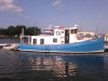
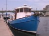
38' Dix designed steel hull/alum structure, single Lehman, sleeps 5-7 easily.
1200nm fuel range.
Great Loop veteran & has done Chesapeake to Ft Lauderdale at least 6 times, Wilmington, NC to Bahamas 3 times.
Fun, Fun & Fun!
She bounces between Wilmington & Abaco... (Probably not going back to Man O' War anytime soon
)
Last edited:
WOW............. Thanks for the info, very nice, and glad you get to spend time on her. I hope to have more time on the Breeze in the coming years....... No Great Loop for me however, I don't have that much time..........
Best we can do now is from Charleston to Wilmington..............
Best we can do now is from Charleston to Wilmington..............